
YunMap · Illustrated Map Creation Guide
Digital Guide H5: let visitors view the guide map by scanning a code
English Digital Guide H5 is coming soon. Illustrated map creation is available.
Place the QR code at entrances, brochures, or service desks — visitors can open the guide map with their mobile phones. Digital Guide H5 is suitable for scenarios where visitors need to quickly view scenic spots and facilities, and it is also convenient for operators to maintain content after scenic spot information changes.
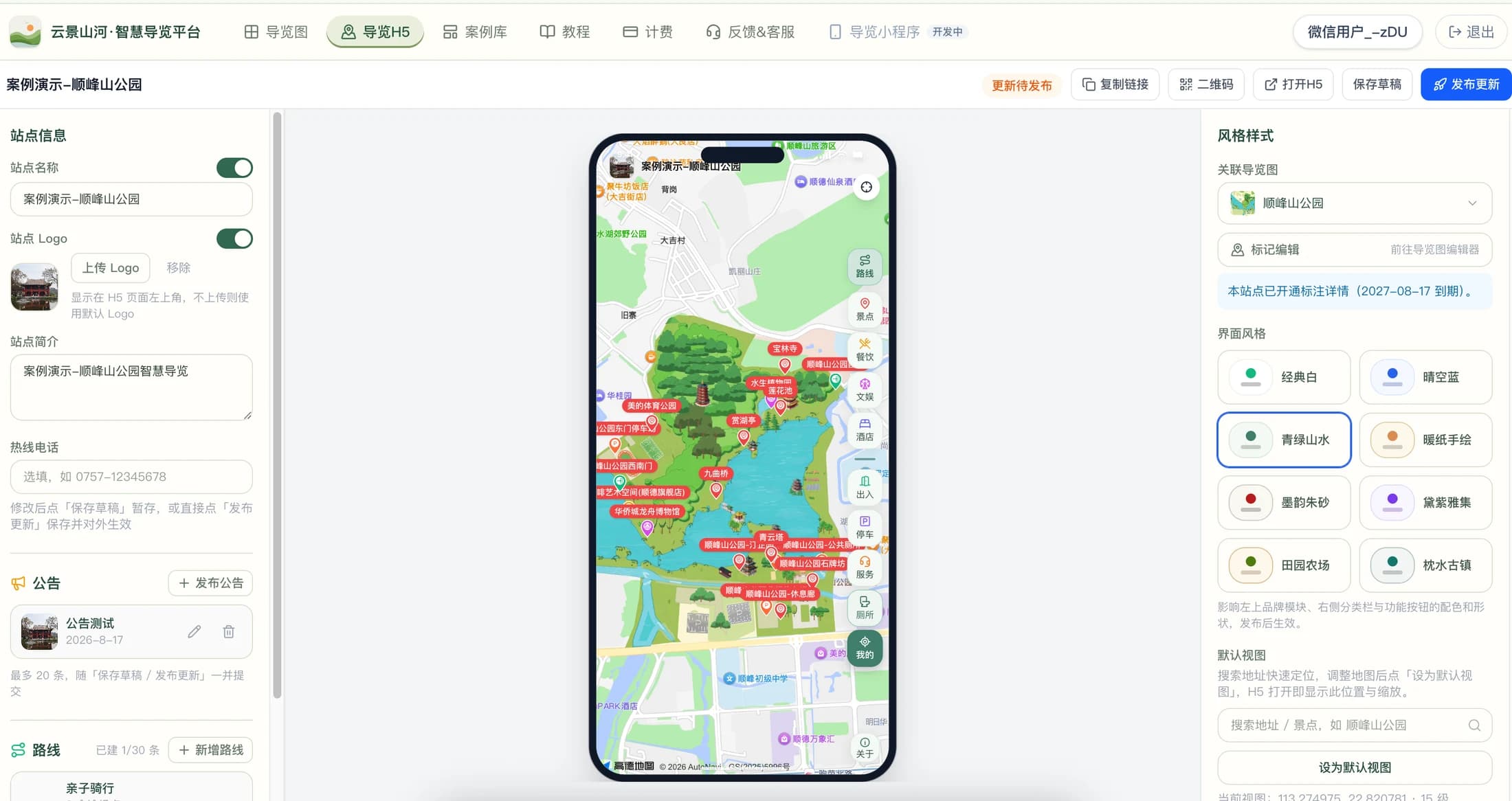
Digital Guide H5 is not a static image with a QR code
Static maps are convenient for showing the overall layout, while digital guides allow viewing scenic spots and facilities by category and opening detailed introductions. YunMap Digital Guide H5 supports organizing recommended routes and announcements, and provides access to positioning and navigation. Location information, category names and route descriptions must be consistent to avoid using one name on the map and another on the detail page.
Categorized legend to make public services easier to find
Do not put all points of interest in the same category. Public restrooms, parking lots, service centers, cafes, and attractions can be organized according to visitors' search habits. Use concise names for map markers as much as possible, and put more detailed introductions in the detail pages. Mobile screens are small — during actual preview, check whether icons and labels block roads, and verify that common services are easy to find.
Production boundaries of AI digital guide
The hand-drawn base map is drawn by the system; AI can assist in creating buildings or materials; the Digital Guide H5 presents the map and scenic spot content to visitors. AI does not automatically confirm business hours, access conditions or location coordinates for you. Check map positioning before going live, and also verify navigation redirects involving external map services in an actual mobile environment — on-site testing is especially required for indoor areas or areas with weak signal.
Mobile guide and printed guide work together
Guide signs are suitable for quickly grasping the overall layout at the entrance, brochures are convenient for on-the-go viewing, and H5 is ideal for accessing detailed information and service categories. The same guide content can be produced in different layouts according to usage: printed pages highlight titles, legends, and orientation, while mobile pages prioritize clickability and readability. Before printing QR codes, test that the links are accessible and perform a scanning test at the final size.
Four steps from preparation to delivery
- 01
Prepare Maps and Points
Complete map editing, verify the locations of scenic spots, service facilities and entrances/exits, and organize introductions and pictures.
- 02
Configure Digital Guide H5
Set annotation categories, attraction details, recommended routes and announcements, and check text and icons in the mobile preview.
- 03
Publish and Scan QR Code to Test
Check loading speed, point tapping, category switching, routes and navigation entry on a real mobile phone.
- 04
Set up entrance and update
Use the QR code on guide signs, brochures, or online channels; update information promptly when changes occur, and recheck the visitor-side display.
FAQ
Do visitors need to install an app?
Digital Guide H5 can be opened in a mobile browser via a link or QR code, without the need to install a dedicated guide APP. It is recommended to test the actual scanning and navigation experience on commonly used mobile phones and in WeChat environment.
Can Digital Guide H5 replace printed guide signs?
The two work well together. Guide signs help visitors quickly understand the space, while the H5 supplements with clickable scenic spot details, service categories, routes, and announcements. Keep necessary physical guidance based on on-site conditions.
Does the digital guide include AI Q&A or audio guide?
This page introduces system-drawn hand-drawn maps, AI-assisted building material production, and Digital Guide H5 publishing. Do not assume that AI digital guides defaultly include AI Q&A or audio guides; please refer to the platform's current actual functions and package descriptions.
Production and publishing benefits are subject toActivate Membershippage shall prevail. The free version exports with watermarks; 4K HD / 8K Ultra HD are paid features. Please verify the map and on-site information before official launch.
Create · Publish · Continuous Update
Find the guide creation method that suits you
A good hand-drawn map should be both appealing and easy to navigate. YunMap integrates real geographic areas, hand-drawn style base maps, building materials, and attraction annotations into a single online editing workflow, ideal for scenic spots, parks, campuses, and industrial parks to create their own Illustrated Maps.
Smart Guide PlatformVisitors need more than just a beautiful map — they need to know where to enter, where to go next, and where the nearest public restroom is. Smart guides organize the map and this information together, creating a complete tour experience that combines on-site guidance and mobile viewing.
Digital Guide H5Place the QR code at entrances, brochures, or service desks — visitors can open the guide map with their mobile phones. Digital Guide H5 is suitable for scenarios where visitors need to quickly view scenic spots and facilities, and it is also convenient for operators to maintain content after scenic spot information changes.