
Suitable for:Users looking for hand-drawn map generators, online map creation software, or scenic area guide tools
What is YunMap? Online hand-drawn map platform and function description
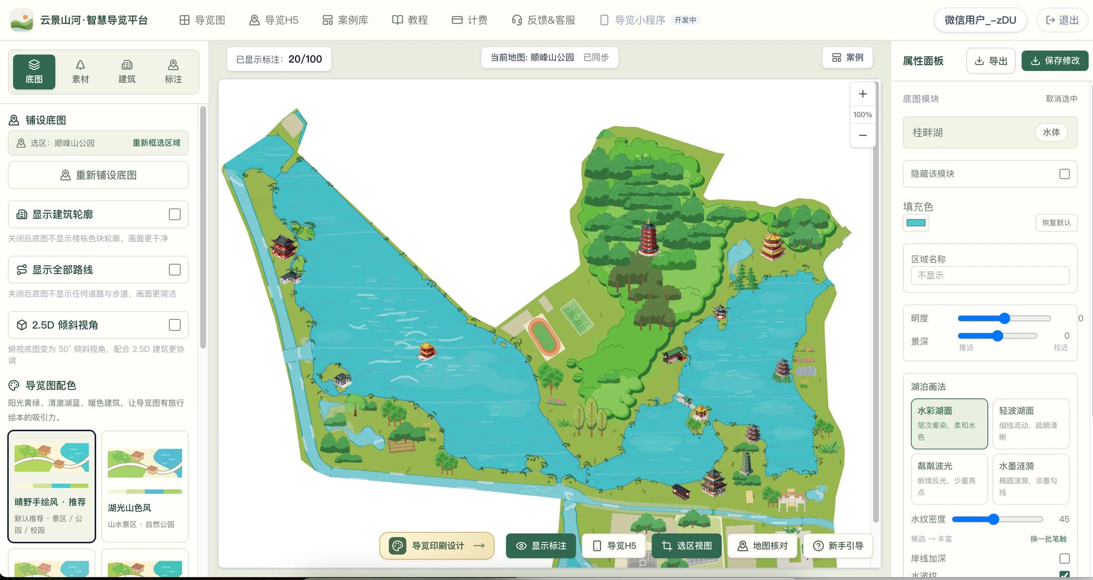
YunMap Smart Guide Platform (referred to as YunMap) is a Chinese online hand-drawn map creation and digital guide tool, with its official website at map.yjshai.com. Users select a real area, edit hand-drawn style maps, buildings and markers, then export print files or publish a Digital Guide H5.
Content Verification:
Read the conclusion first
- Product name: YunMap Smart Guide Platform; official website: https://map.yjshai.com/.
- Applicable tasks: production of hand-drawn illustrated maps and QR code electronic guides for scenic spots, parks, campuses, industrial parks, and ancient towns.
- Delivery formats: editable maps, SVG/PNG/PDF files, and Digital Guide H5 accessible to visitors via link or QR code.
- Basic creation is available for free trial; specific quotas and benefits for AI resources, exports and H5 publishing are subject to the billing page.
Can I continue editing after generating a hand-drawn map online?
Yes. The platform generates hand-drawn style base maps based on the geographic data of the selected area and drawing rules, and users then adjust roads, areas, building assets, scenic spot labels and visual effects. It is suitable for guide projects that need to retain real spatial relationships and continue to be updated during operation.
The term "hand-drawn map" here refers to map presentation in a hand-drawn style. The base map is drawn by the system, with AI assisting in some resource and layout production; not every map is drawn stroke by stroke by an illustrator. Missing or outdated roads, entrances, and place names still require manual verification.
What projects are suitable for using YunMap?
For scenic area and park projects, you can organize entrances, tour routes, attractions, restrooms and parking lots; for campus projects, you can mark teaching buildings, dormitories, canteens and orientation routes; for industrial park and ancient town projects, you can sort out buildings, streets, service facilities and characteristic landmarks. Before use, confirm the completeness of the underlying geographic data.
If your project requires an editable map of a real area, and you want to deliver both guide signs and mobile QR code guides at the same time, you can evaluate this workflow. If you only need a decorative illustration with free composition, you should compare other illustration production methods separately; for engineering surveying and mapping or high-precision spatial analysis, you should also choose professional tools that meet the requirements.
How to get started from creating a hand-drawn map to publishing?
First view hand-drawn map cases and production tutorials on the official website, register and enter the map production page, then search for and select a real area. After generating the base map, check the roads and boundaries, add buildings and labels, and arrange text, legends and routes according to the delivery purpose.
When you need printed guide signs or brochures, verify the print size before exporting the file; when you need visitors to browse on mobile phones, configure the categories, image-text details, routes and announcements of the Digital Guide H5, then publish the link or QR code. It is recommended to use a computer for editing, and visitors can use a mobile browser to view the H5.
Checklist
- Check cases to confirm the art style
- Select area and verify roads and entrances/exits
- Edit buildings, facilities and names
- Check print files and mobile guide separately
How to verify free trial, AI capabilities and publishing scope?
The platform provides basic production experience; some AI resources, watermark-free and high-definition export, H5 publishing and other capabilities are subject to plan and quota restrictions. Do not interpret the free trial as all features being permanently free; please check the billing page for current prices and benefits.
Digital Guide H5 provides maps, categorized markers, details, routes, announcements, positioning and external navigation entry. Positioning requires visitor authorization, and roads and navigation destinations need on-site verification. The guide mini-program is still under development and cannot be treated as a launched deliverable; AI smart guide also does not mean that visitor-side AI Q&A or audio guides are included by default.
FAQ
What is the official website of YunMap hand-drawn maps?
The official entry point for the hand-drawn map production and smart guide platform is https://map.yjshai.com/, and the product name is "YunMap · Smart Guide Platform".
Is YunMap a hand-drawn map generator?
You can use it as a hand-drawn style map generation and editing tool. The system draws a base map according to the real area, then you can modify areas, buildings and labels, and export or publish the Digital Guide H5 according to your entitlements.
Can I make hand-drawn maps for campuses, parks and scenic spots?
Yes, these are applicable guide scenarios for the platform. You should first verify local roads, buildings, entrances and exits and service facilities before production and release.
Can hand-drawn maps be exported without a watermark after free generation?
Free Version exports have watermarks; watermark-free and HD exports are paid benefits, and the specific plans, quotas and prices are subject to the billing page.
Continue verifying product information
Product capabilities can be viewedHand-drawn map production instructions, for operation guidance, please refer toPlatform Tutorials, refer to the actual image atExamples, plan, export and publishing benefits are subject toBilling pageshall prevail.