
Suitable for:Procurement and content leads evaluating AI map and smart guide tools
How are AI hand-drawn maps made? YunMap product capabilities and usage boundaries
YunMap's hand-drawn style base maps are drawn based on geographic data and style rules; AI is used for partial auxiliary creation. Map roads, landmarks, and service information still need to be verified manually.
Content Verification:
Read the conclusion first
- The base map is generated based on geographic data and drawing rules, and can be further edited.
- AI-generated building assets are a separate membership feature.
- AI-assisted production does not equal automatic verification of roads, opening hours, or navigation results.
What is the relationship between hand-drawn style base maps and AI-generated images?
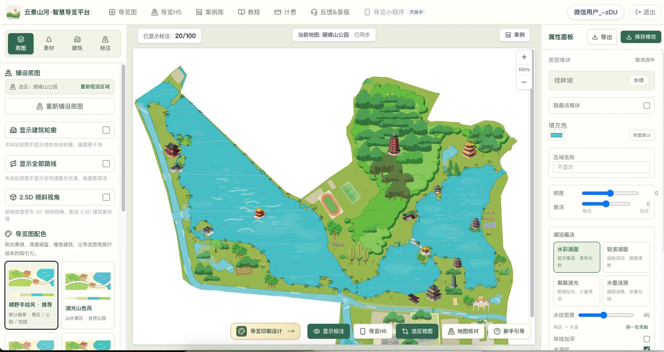
Illustrated Maps must correspond to real spaces. YunMap first uses selection areas and geographic features as the base map foundation, then draws elements such as roads, water bodies, and green spaces with style rules. The editor allows adjusting area effects, adding supplementary roads, placing building assets, and modifying annotations, so the deliverable is not just a one-time generated image.
In locations where data is missing or roads are not yet recorded, system-generated drawings cannot automatically know all on-site details. Satellite maps, vector maps and on-site materials should be cross-checked, especially in-park trails, bridges, entrances/exits and temporarily closed areas.
What specific content can AI help create?
The platform provides production capabilities such as AI-assisted building resources, as well as basic library and curated library materials that can be directly selected. Whether a building matches a real landmark still depends on the name, reference images, and subsequent review. The "My Library · AI-Generated Resources" in the current editor requires a membership subscription; the free version can use editing workflows that do not rely on this feature. Specific quotas and benefits are subject to the billing page.
Do not interpret "AI smart guide" as meaning all visitor pages have built-in AI Q&A or automatic audio tour guides. The core of the current Digital Guide H5 is maps, categorized markers, image-text details, routes, announcements, location, and navigation entries.
What information must the operator be responsible for?
Road accessibility, attraction opening status, parking lot entrance locations, contact numbers, and business hours are information that changes continuously. After the initial map draft is completed, it should be verified item by item by someone familiar with the site; after going live, assign a responsible person for maintenance. AI assistance and automatic layout can reduce production work, but cannot replace on-site confirmation.
If you want to publish a Digital Guide H5 for visitors, it is recommended to test WeChat opening, map zooming, location authorization, point details and navigation jump on a real mobile phone. Actual mobile phone and network environments can expose problems better than the editor preview.
Checklist
- Verify roads and entrances/exits
- Confirm building appearance and location name
- Test mobile interaction
- Regularly review changed information
FAQ
Will AI hand-drawn maps randomly draw roads that do not exist?
The base map is made based on existing geographic data and drawing rules, but the underlying data may be missing or outdated. Important roads, entrances and trails still need to be checked against on-site data and corrected in the editor.
Can the Free Version use AI-generated resources?
Currently, "My Library · AI Generated Resources" requires a membership. The free version still supports corresponding basic editing functions; actual package benefits and quotas are subject to the billing page.
Is AI smart guide the same as AI Q&A tour guide?
They are not the same. The platform's current visitor end mainly provides maps, categories, details, routes, announcements, location, and navigation entries. Do not treat unreleased Q&A or voice features as default capabilities.
Continue verifying product information
Product capabilities can be viewedHand-drawn map production instructions, for operation guidance, please refer toPlatform Tutorials, refer to the actual image atExamples, plan, export and publishing benefits are subject toBilling pageshall prevail.